Show Tags
Catalog Detail
CREATOR | World War, 1939-1945 | Maj. Gen. William Levine Collection | World War, 1939-1945 - Campaigns | France - Normandy - Maps | Carentan (France) - Maps | Military campaigns | France - Carentan | France - Normandy | 1939-1945 | Military maps | Maps | United States. - Army. - Engineer Topographic Battalion, 660th
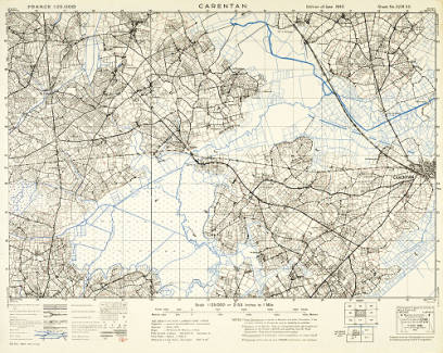
Carentan: France 1:25,000
- Creator: CREATOR.
Relief shown by contours, spot heights, and pictorially.
- OCLC #: 847682268
- Call #: G5834.C424 S7 1943.G7
- Physical Location: Special Collections — Flatfile Storage — MAP 00110
- Personal Collection:
- Maj. Gen. William Levine Collection
- Production, Publication, Distribution, Manufacture, and Copyright Notice: [London] : War Office, 1944.
- Edition:
- Edition of June 1943.
- Series Statement:
- G.S.G.S. ;
- Physical Description: 1 map : color ; 40 x 60 cm on sheet 50 x 62 cm.
- General Notes:
- Relief shown by contours, spot heights, and pictorially.
- Shows roads, bridges, railroads, power cables, rivers, streams, canals, and other features of interest. Includes overprint in red, blue, and purple showing defense information.
- "Sheet no. 31/18 S.E."
- "Compiled from Air Photographs on a control provided by existing French Triangulation."
- "3,000/7/44 660th."
- Includes index to adjoining sheets and incidence of 1:50,000 sheets.
- Shows roads, bridges, railroads, power cables, rivers, streams, canals, and other features of interest. Includes overprint in red, blue, and purple showing defense information(?).
- Electronic Access: